Training on monitoring dangerous natural and man-made geoprocesses in the cross-border territory took place at UzhNU

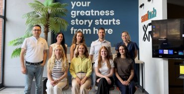
On November 2-3, 2022, Uzhhorod National University hosted a training as part of the international project "Extension of the operational "Space Emergency System“ towards monitoring of dangerous natural and man-made geo-processes in the HU-SK-RO-UA cross-border region (GeoSES)”
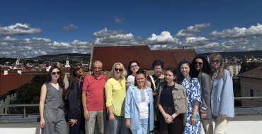
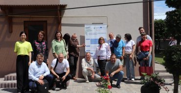
The event began on November 2nd in the hall of the Academic Council of UzhNU and continued the next day in the village of Solotvyno. Leading domestic and foreign scientists, representatives of executive and local self-government authorties, specialists of regional organizations and institutions working in the field of geodesy and cartography joined the training.
The project, within the framework of which the training took place, is implemented under the Hungary-Slovakia-Romania-Ukraine ENI Cross-border Cooperation Programme 2014-2020 funded by the EU. The main results of the project, which have already been achieved, include carrying out comprehensive assessment of threats and risks in the Carpathian region, processing data from geomonitoring of dangerous landslides and mudflows in the Tysa River valley, forecasting the occurrence of heavy rains in border areas to prevent floods, developing a joint innovative strategy to prevent environmental disasters in the Carpathian region.
The planned results have been achieved thanks to the joint and coordinated work of the project partners: SU “Uzhhorod National University” (Ukraine) the Department of Foreign Affairs and Regional Development of the Department of Tenders and Projects of the General Assembly of the Szabolcz-Szatmar-Bereg County (Hungary), Pavol Jozef Šafárik University in Košice, (Slovakia), Technical University of Cluj-Napoca (Romania), Budapest University of Technology and Economics (Hungary).
The event was opened by the Vice-rector for Research of Uzhhorod University, Doctor of Sciences (medicine), professor Ivan Myronyuk, who emphasized the importance of international cooperation for the development of science, especially considering present day realities. After all, Ukraine, having acquired the status of a candidate country for joining the EU, has to work twice as hard to get integrated into the European community, including the fields of research and education. Grant support, as one of the tools of cross-border cooperation, is always an additional basis for the implementation of innovative ideas in research.
The head of the Department of Urban Planning and Architecture of the Transcarpathian Oblast Administration, the chief architect of the Transcarpathian Region, Mykola Pigulyak, shared this opinion, adding about the international projects implemented by his department in the field of climate change prevention and adaptation to them.
During the training, Doctor of Technical Sciences, professor of Uzhhorod University, coordinator of the project Nataliya Kablak dwelt upon the topic of geodetic monitoring of natural and man-made processes in the territory of Solotvyno, in particular in the area of the salt mine.
Stepan Savchuk, Ph.D., professor of the Department of Higher Geodesy and Astronomy of Lviv Polytechnic, informed the audience of the results of modern geodynamics research on the territory of Solotvyno based on geodetic monitoring data.
Volodymyr Glotov, Ph.D., professor, the head of the Department of Photogrammetry and Geoinformatics of Lviv Polytechnic, spoke about the methods of using UAVs as an alternative to space photography for investigating emergency situations.
The Hungarian partners - the project manager, Dr. Rozsa Szabolcs, associate professor of Budapest University of Technology and Economics, and Roland Horvath, researcher of the Satellite Geodetic Observatory of Pécs - shared their experience of carrying out tomographic reconstruction of atmospheric water vapour in the cross-border region of the Carpathians.
Integrated solutions for geomonitoring of landslides, as the main results of the GeoSES project were discussed by the participants of the training at the initiative of the project manager from the Romanian partners, Dr. of Technical Sciences of Technical University of Cluj-Napoca, Adrian Radulescu, and Honorary Professor, Doctor of Technical Sciences of the same university, Gheorghe Radulescu.
Professor Corina Radulescu from the Faculty of Economics and Physics of Technical University of Cluj-Napoca emphasized communication - another important component of natural disaster risk management.
The executive manager of the project Ivan Kalynych (Ph.D., associate professor) and the director of the Transcarpathian branch of the SE "UkrSAGE" Ivan Prodanets spoke about preventing the occurrence of risks of natural disasters.
Dr. Jan Kanyuk, the head of the geographic information systems laboratory of the Faculty of Natural Sciences of Pavel Jozef Šafarik University in Košice (Slovakia), shared the results achieved during the implementation of the project by the Slovak partners.
Particular attention and interest of the participants was aroused by the speech of Brigitta Majorne László, the referent of the department of foreign affairs and regional development of the department of tenders and projects of the self-governing authority of Szábolcz-Szatmar-Bereg County of Hungary, who spoke about the Joint Climate Strategy for the cross-border region Hungary-Slovakia-Romania-Ukraine, which could become a road map for the next actions of scientists, public and local authorities in the field of environmental protection and prevention of ecological disasters.
An important element of the results of the project implementation is the website, which will include a complex geo-information system in a unique integrated database about the environment. The web resource of the project will be created on the same platform as the geoportal of the urban cadastre of the Transcarpathin region. This will make it possible to organize an effective exchange of geospatial data between these two information resources. Maksym Pavley, the head of the urban planning department of the urban planning and architecture authority of the Transcarpathan Oblast State Administration, told the participants about this.
The event ended with the ceremonial handing over of the Memorandum of Undestanding between the participants of the Geoinformation Technologies (GIT) Scientific and Educational Consortium.to Lviv Polytechnic National University. It was signed by the heads of eight higher education institutions of Slovakia, Romania, Hungary, Poland and the Czech Republic.The Consortium is a voluntary association of universities and research institutions of Ukraine and EU member states, created to coordinate efforts with the aim of achieving the world level in the priority areas of development of geo-information technologies, support of sustainable development, modernization of higher education in the field of HIT and training of highly qualified personnel for scientific and educational institutions